


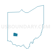
PRECINCT FAIRBORN 212, Greene County, Ohio
About
Outline

Summary
| Unique Area Identifier | 646795 |
| Name | PRECINCT FAIRBORN 212 |
| County | Greene County |
| State | Ohio |
| Area (square miles) | 0.94 |
| Land Area (square miles) | 0.94 |
| Water Area (square miles) | 0.00 |
| % of Land Area | 100.00 |
| % of Water Area | 0.00 |
| Latitude of the Internal Point | 39.79596110 |
| Longtitude of the Internal Point | -84.00970610 |
Maps


Graphs
Select a template below for downloading or customizing gragh for PRECINCT FAIRBORN 212, Greene County, Ohio


Neighbors
Neighoring Voting District (by Name) Neighboring Voting District on the Map
- PRECINCT FAIRBORN 209, Greene County, OH
- PRECINCT FAIRBORN 210, Greene County, OH
- PRECINCT FAIRBORN 211, Greene County, OH
- PRECINCT FAIRBORN 213, Greene County, OH
- PRECINCT FAIRBORN 214, Greene County, OH
- PRECINCT FAIRBORN 215, Greene County, OH
- PRECINCT FAIRBORN 217, Greene County, OH
- PRECINCT FAIRBORN 226, Greene County, OH
Top 10 Neighboring County Subdivision (by Population) Neighboring County Subdivision on the Map
Top 10 Neighboring Place (by Population) Neighboring Place on the Map
Top 10 Neighboring Unified School District (by Population) Neighboring Unified School District on the Map
Top 10 Neighboring State Legislative District Lower Chamber (by Population) Neighboring State Legislative District Lower Chamber on the Map
Top 10 Neighboring State Legislative District Upper Chamber (by Population) Neighboring State Legislative District Upper Chamber on the Map
Top 10 Neighboring 111th Congressional District (by Population) Neighboring 111th Congressional District on the Map
Top 10 Neighboring Census Tract (by Population) Neighboring Census Tract on the Map
- Census Tract 2009, Greene County, OH (5,655)
- Census Tract 2005, Greene County, OH (5,048)
- Census Tract 2001.03, Greene County, OH (3,713)
- Census Tract 2006, Greene County, OH (3,557)